|


| |
Soda Bottle Hydrology
U.S. Department of Energy

Office of Environmental Management
and
HAZWRAP

By
Terence W. Cavanaugh & Catherine Cavanaugh
June, 1993

Soda Bottle Hydrology
Table of Contents
Soda Bottle Hydrology
Materials
 | 2-liter soda bottle
| 10 cm by 10 cm square of nylon screen
| Sand (use playground type sands), different colors if available
| Rocks (various small sizes)
| Clear drinking straws
| Film can (plastic)
| Volumetric container (beaker, measuring cup, graduated cylinder, etc)
| Boric Acid (powdered: obtain at local drug store or hardware store)
| Indicators: chocolate X-lax (phenolphthalein)
| Food coloring
| Nail (large)
| Tape (clear)
| Water based marker
| Permanent marker
| Fertilizer (water soluble , green x-tal)
| Scissors
| Water
| Clock
| Ice
| Pan (or dish)
| Plastic cup (clear)
| Liquid dish washing soap
| Metric measuring cup (or other material able to measure in 100 mL increments)
| | | | | | | | | | | | | | | | | | | | | | |
Soda Bottle Hydrology
Pre-Lab Construction:
Materials
2 two-liter clear soda bottles, 1 plastic film canister, 1 ruler (cm), permanent marking pen, scissors, rubber band, nylon screen (10 cm X 10 cm), metric measuring cup.
Procedure:
- Remove the labels from the bottles.
- Choose which bottle will become the model bottle (will cut bottom off) and which will become the collection bottle (will cut top off).
- Add water 100 mL at a time to the bottles .
- Use the permanent marker to mark the volumes onto the bottles and label the bottles in 100 mL increments.
- On the collection bottle 4 centimeters below the neck ring cut off the top of the bottle.
- On the model bottle 5 centimeters up from the bottom cut off the base. (note: save the bottom of the model bottle for later labs)
- Fold or wad up the 5 cm X 5 cm nylon screen and insert into the neck of the model bottle.
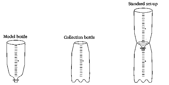
Table of Contents
1. The Hydrologic Cycle:
Materials
Sand, Water, Ice, Model Bottle, Water Based Marker, Bottle bottom.
Background:
Scientists call the constant endless movement of water from the atmosphere to the earth to
groundwater to river to ocean the hydrologic cycle. How long it takes water that falls from the clouds to return to the atmosphere varies greatly. Scientists predict it would take nine days to replace all of the atmospheric water and 37,000 years to replace all of the water in the oceans. In this activity we will create a hydrologic cycle.
(hydrologic cycle)
Procedure: 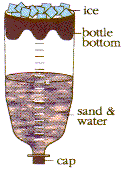
- Screen and cap the model bottle.
- Fill your model bottle with sand to the one liter mark.
- Slowly pour in 200 milliliters of water.
- Allow the water to settle.
- Put the bottle bottom into the top of the model bottle, so you can add material to the bottle bottom.
- Put some crushed ice into the bottle bottom (which is at the top of the model bottle).
- Set the bottle in some sunlight and observe.
- With your marker draw and label on the model bottle the following:
 | Ground water
| Surface water
| Evaporation
| Condensation
| Precipitation
| | | | |
Draw the hydrologic cycle on to a piece of paper.
Clean up.
Table of Contents
2. Porosity
Materials:
Sand, Water, Model Bottle, Collection Bottle.
Background:
Is something ever empty? If you take a glass from the shelf, is it empty or full of air? If you fill the glass with sand is the glass now full or can you still put material into it (like water)?
Porosity deals with the space between materials (like sand, rocks, marbles, or molecules) which have enough open spaces for water to move through. These spaces are called pores. Each material has a unique number of pores, or pore volume, which cause the water to move through it at different rates. In this experiment you are going to measure the pore volume in a one liter sample of sand. The sand in these activities represents an
aquifer. An aquifer is the porous rock structure that holds water underground. If we know the
porosity of our aquifer and how big the aquifer is we can calculate the volume of water stored in that
aquifer. In an actual aquifer, porosity will decrease with depth because of compaction caused by the overlying rock layers.
(porosity, aquifer)
Procedure: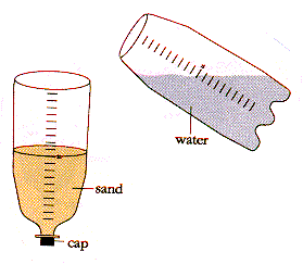
- Screen and cap the ground water model bottle.
- Fill your ground water model bottle with dry sand to the one liter mark.
- Fill the volume/catch bottle to the one liter mark with water.
- Slowly pour water into the sand until you can see water staying on the surface of the sand.
- Find the current volume on the volume/catch bottle and record.
- Remove the cap from the model bottle and allow the water to drain and the sand to dry.
Data/Calculations:
Data/Calculations:
	Start Volume - Finish Volume = Pore Space Volume

	1000 milliliters -               =            milliliters

	Pore volume in a liter of sand is _______________________.

	(Volume of pores/Total rock volume) X 100 = porosity (%)

	(                /1000 ml) X 100 =                    %
Table of Contents
3. Permeability
Materials:
Sand, Water, Model Bottle, Collection Bottle, Timer (clock).
Background:
How does water move through something? That question is in part answered by permeability. Permeability is the measure of how easily water can flow through a material (like an aquifer). We pump our drinking water from the
groundwater in an aquifer, the layer of porous rock or soil under the earth's surfaces which collects water. As we pump water out of an aquifer more water will flow in to take its place during recharge.
Recharge adds water to the groundwater system when rainfall, melting snow, surface water, or water from a creek or lake soak in through the soil and rocks. Since water flows slowly in rock, recharging the aquifer
takes time. In this lab we will measure the permeability of water through sand to represent the movement of water in a
aquifer.
(permeability, groundwater, aquifer,
recharge aquifer)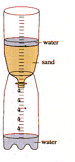
Procedure:
- Put one liter of sand into the model bottle and insert the screened end of the model bottle into the collection bottle.
- Slowly pour water into the model bottle, try to keep the water level 100 mL above the sand.
- When water starts to come out of the model bottle and into the collection bottle start timing.
- Continue to add water to the model bottle keeping all of the sand wet.
- When the collection bottle reaches one liter stop timing and record the time.
- Pour out the water from the collection bottle and make the setup again so the model bottle can drain and dry.
Data/Calculations:
Start time:                          		Stop time:
	 Hour   Minute Second	    	Hour    Minute Second

Time for one liter to flow through the sand:
		    Hour   Minute Second
	   Stop time

     	- Start time
	 ______________
    	 = Flow time		(don't forget only 60 seconds in a minute)


Permeability flow rate should be expressed as a volume per time (liters per minute).

	1 liter of water divided by the		     1 liter     	                =
	time for 1 liter to flow (minutes)		 ________ minutes =
Table of Contents
4. Parts of an Aquifer
Materials:
Sand, Water, Model Bottle, Collection bottle,
Water based marker, Food coloring,
Background:
. Whenever water reaches the ground some of this water goes into the ground, where it flows through porous rocks. Groundwater is divided up into layers called the saturated zone of (full of water) the water table (the top of the zone of saturation), and the unsaturated zone (everything above the water table). As water flows through the ground some water sticks to the surface of the rocks and soil in the unsaturated zone, but the pores in the rock or soil in the zone are filled with air. The water continues to flow down through the water table to the
saturated zone where all the pores in the rock or soil are filled with water. In this activity we will use
capillary action to lift water up into our sand aquifer.
(unsaturated zone, water table, saturated zone,
capillary action, aquifer)
Procedure: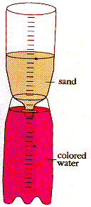
- Screen the model bottle.
- Fill your ground water model bottle with sand to the one liter mark.
- Slowly pour in approximately 1800 milliliters of water into the collection bottle.
- Add food coloring to the water (about 6 drops of a dark color).
- Observe.
- With the marker draw on the bottle the following:
| Water table
| Zone of saturation
| Zone of aeration
| | |
Draw the structure on to a piece of paper.
Approximately how much water was drawn up into the model bottle?
(collection volume start - collection bottle finish = capillary action volume)
Define capillarity.
Table of Contents
5. The Recharge Zone
Materials:
Model bottle, Sand, Water, Film canister (with bottom cut off), Collection bottle, Water based marker, Food coloring.
Background: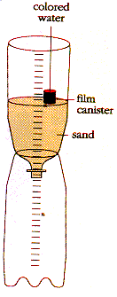 Recharge zones (sometimes called green zones) are where water flows into the ground to become
groundwater through the recharge system. Recharge adds water to the groundwater system when rainfall, melting snow, surface water, or water from a creek or lake soaks in through the soil and rocks. In a recharge zone, water flows downward through the
unsaturated zone, water table, and saturated zone to get to the aquifer. In this experiment we will observe the structure of the downward flow of water into an
aquifer, which we will create using sand.
Recharge zones (sometimes called green zones) are where water flows into the ground to become
groundwater through the recharge system. Recharge adds water to the groundwater system when rainfall, melting snow, surface water, or water from a creek or lake soaks in through the soil and rocks. In a recharge zone, water flows downward through the
unsaturated zone, water table, and saturated zone to get to the aquifer. In this experiment we will observe the structure of the downward flow of water into an
aquifer, which we will create using sand.
(recharge zones, groundwater, unsaturated zone, water table, saturated zone aquifer)
Procedure:
- Screen the ground water model bottle, and insert into the collection bottle.
- Add to your model bottle one liter of sand.
- Insert the film canister into the sand, next to the wall of the bottle.
- Slowly pour colored water into the film canister.
- Observe the flow of the colored water into the sand.
- With your marker, draw on the bottle the flow pattern of the water.
- On a piece of paper diagram the flow pattern you saw in the bottle.
- Explain why you think it forms this pattern.
- Clean up.
Table of Contents
6. The Discharge Zone
Materials:
Sand, Water, Model Bottle, Nail, Pan, Clear Tape, Water based marker, Food Coloring (yellow works well).
Background:
Sometimes water naturally flows out of the ground, like a spring or geyser; some times it is pumped out of the ground with a well. The area where water flows out of the ground is called a discharge zone. If the water table, the top surface of the saturated zone which separates it from the unsaturated zone, is to stay level the amount of water
recharged (coming in to the ground) must equal the amount of water discharged (going out of the ground). In this experiment we will create a discharge zone by putting a hole in the side of our model bottle (modeling an
aquifer). We will be able to follow what is happening with the water by using food coloring as a
tracer. A tracer is a material which gives information concerning the direction of movement and/or the velocity of the water and potential contaminants which might be transported by the water.
(recharged, discharge zone, aquifer,
tracer)
Procedure: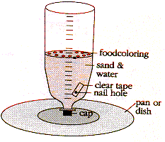
- Heat the end of a long nail with a candle.
- Poke a hole in the model bottle, with the hot nail, at about the 500 ml mark.
- Cover the hole with clear tape on the outside of the bottle.
- Add one liter of sand to the model bottle.
- Cap the bottle then slowly pour water into the model bottle, until the aquifer is full.
- Place the model bottle over a pan.
- Place drops of food coloring along the edge of the sand next to the bottle (6-8 drops)
- Remove the tape.
- Observe the flow of water through the sand.
- If the water isn't flowing, add some more water.
- With your marker, draw on the bottle the flow pattern of the water.
- On a piece of paper diagram the flow pattern you saw in the bottle.
- Explain why you think it forms this pattern.
- Clean up.
Table of Contents
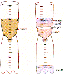
7. Sedimentary Rock and Core Sampling
Materials:
Sand (various colors), Clear plastic straws, Model bottle, Water.
Background:
Sedimentary rock is where aquifers are usually located. Sedimentary rocks form underwater. Over 70% of the Earth's surface is covered by sedimentary rock. Sand, silt or some other material is deposited and then gets compressed by the layers of material on top, making rock. Sedimentary rock forms in layers. Some layers are very
permeable (like limestone) while others are only slightly permeable (like clay). Scientists who want to know what the rocks are like under the ground take a core sample-- they drive a hollow tube into the ground and then pull it up and look at the rock and material contained within the tube. In this experiment we will lay down layers of sand (to symbolize
sedimentary material) and then take a core sample.
(sedimentary rock, permeable)
Procedure: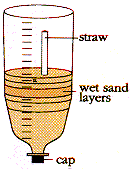
- Put the cap onto the model bottle.
- Pour in 500 milliliters of dry sand.
- Add water to the model bottle until the water reaches the one liter mark.
- Add (sprinkle) in different types of sand one layer after another, alternating the colors/sands until the sand reaches the 800 milliliter mark.
- Uncap the model bottle and insert into the collection bottle to allow to drain.
- Observe and on a piece of paper draw the layered design from the side of the bottle.
- Slowly push a clear straw, into the top of the moist sand, as deep as possible.
- Cover the top of the straw with your finger and pull the straw out.
- Observe and draw the structure you see in the straw.
- How or why is the straw's pattern of layers different from that of the bottle?
- Clean up.
Table of Contents
8. Solubility
Materials:
Sand, Water, Drinking straw, Model bottle, Plastic cup (clear), Lime (from a hardware/garden store).
Background:
Solubility is a solid's tendency to dissolve. If the minerals making up the rock or materials put into the ground (like trash, fertilizer, pesticides, etc.) are
soluble, then those will end up in the groundwater. At some point the groundwater
cannot dissolve any more minerals because it is completely full, or saturated. In this activity we will dissolve lime (a substance make from rock) into our
groundwater. When the lime dissolves it cannot be seen, but that does not mean that it is not there. We can test for the presence of lime in our water by running a chemical test. In this case all we have to do is blow bubbles (which contain carbon dioxide, which reacts with lime) into the water. If lime is present then a white precipitate will form, causing the water to turn cloudy.
(soluble, groundwater, saturated)
Procedure: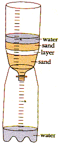
- Add to the screened model bottle 500 mL of clean dry sand.
- On top of the 500 mL of sand add 100 mL of lime.
- On top of the lime continue adding sand until you reach the one liter mark.
- Put the model bottle over the cup, so that the cup can catch water coming out of the model bottle.
- Slowly pour water into the model bottle.
- Collect water in the cup, until it is about half full of "water".
- Set the model bottle aside so that it can drain.
- Observe the color of the liquid.
- Using the straw slowly blow bubbles into the cup of water.
- Observe the results.
- Clean up.
Color of liquid before bubbling: _______________
Color of liquid after bubbling: _______________
What happened to the water going through the aquifer? ______________________________
Table of Contents
9. Pollution Plumes
Materials:
Sand, Water, Drinking Straw, Model bottle, Collection bottle, Liquid dish soap, Food coloring, Plastic spoon, Dropper.
Background:
Pollution takes many forms and affects us in many ways. Pollution can be caused by contaminants released into the
groundwater. Septic tanks, cess pools, and injection wells intentionally empty substances into
groundwater. If an underground oil or fuel pipeline broke, then fuel would accidentally be released into
groundwater. When you fertilize your lawn, some of those fertilizers go into groundwater.
If someone had a gas station that closed, but there was still some fuel in the underground tanks, those tanks could rust and leak fuel into the
groundwater. When a contaminant gets into the groundwater it will move along producing what is called a
plume, an area of the water which is contaminated. A plume's shape is determined by what the contaminant is and the conditions around it. In this activity we will create a contaminant plume and diagram its shape.
(groundwater, plume)
Procedure: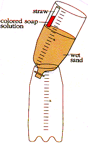
- Add to the screened model bottle one liter of sand.
- Place the model bottle into the collection bottle.
- In a small container mix about one teaspoon of liquid detergent and five drops of food coloring.
- Add water to the model bottle until all the sand is wet.
- Fill a drinking straw about half way with the soap/food coloring mixture.
- Insert the straw into the sand near an edge.
- Tip the model bottle so that the sand where the straw is inserted is higher than the rest of the sand.
- Wait 10 to 15 minutes.
- Diagram the contaminant plume by scraping out 100 mL layer of sand and then drawing the shape seen in the sand left in the bottle (label this line by the volume from the side of the bottle).
- Scrape out another 100 mL of sand and add this shape to your drawing.
- Continue scraping out 100 mL volumes of sand and adding to your drawing until you can no longer see the plume in the bottle.
- Clean up.
Table of Contents
10. Chemical Changes in Groundwater
Materials:
Sand, Water, Model Bottle, Collection Bottle, Rubbing Alcohol, Lime (horticultural), Laxative Tabs (containing
Phenolphthalein) [laxatives containing phenolphthalein are no longer sold, instead consider contacting a high school science teacher for phenolphthalein or other indicators that will change due to a slight acid
level]), Cup, White vinegar, Bottle bottom, Eye dropper (drinking straw will work).
Background:
There are many different kinds of aquifers. The water in the aquifer can react with the rock surrounding it. Some rocks don't react much, like sands, and some react a lot, like
limestone. When water passes through limestone the water becomes slightly basic (pH greater than seven). This is caused by ions coming out of the rock into the water. Some rocks contain sulfates. When water passes through sulfates the water to becomes acidic (pH less than seven). When the
groundwater changes in composition its behavioral properties also change. An acidic water may react with or cause other materials to dissolve that otherwise would not. Even rain has effects. If acid rain is present in an area, then the water entering the ground is already acidic and may react with the surrounding rocks and materials. In this activity we will check the pH (acid or base) of water as it passes through an
aquifer. To check the pH we will use an indicator (phenolphthalein). A chemical indicator is something that changes color depending on its surroundings. Phenolphthalein is clear in acids and turns purple or pink in bases.
(aquifer, groundwater)
Procedure:
- Put 1 or 2 laxative tabs in about half a cup of rubbing alcohol and stir for a few minutes (makes the indicator solution).
[As this form of laxative is no longer sold, contact a local high school science teacher for some indicator, experiment with natural indicators, or use indicators from a pool test kit]
- Pour into your model bottle about 500 milliliters of sand.
- Observe the color of the indicator (put a few drops in one section of the bottle bottom)
- Pour some indicator onto the sand (about 1/4 a cup).
- Add water until water starts to come out into the collection bottle.
- Observe the color of the indicator/water (put a few drops in another section of the bottle bottom).
- Add to the collection bottle about 50 milliliters of horticultural lime (this makes the aquifer limestone), and cover with sand to the 1 liter mark.
- Pour the indicator/water back into the model bottle, and add water until some indicator/water comes out.
- Observe the color of the indicator/water (put a few drops in another section of the bottle bottom).
- Check to see if your indicator /water is basic by taking a small sample of the indicator/water (in the bottle bottom) and adding to that a few drops of white vinegar (acetic acid), and seeing if a color change occurs.
- Clean up.
DATA TABLE
COLOR OF INDICATOR/WATER
| Before pouring into sand _____________________________
| After pouring through just sand __________________________
| After pouring through "limestone" _________________________
| After adding acid to a small sample ________________________
| | | |
You could also make an acidic aquifer by using BORIC ACID, that you can get from a drug store or hardware store, instead of lime. Then pour the indicator/water from the limestone aquifer through the boric acid aquifer and note the changes.
Clean up.
 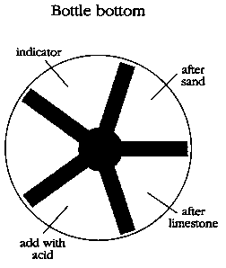
Question: What happens to water as it flows through the ground?
Table of Contents
Glossary
-
Aquifer
- the underground porous rock structure which holds water.
- Condensation
- transition of a substance from vapor to liquid.
-
Discharge
- way in which groundwater flows out of the Earth’s surface (springs, geysers, wells, etc.)
- Evaporation
- the conversion of a liquid into a vapor.
-
Groundwater
- water within the Earth that supplies wells and springs
-
Hydrologic cycle
- the Earth’s endless recycling of water from the atmosphere, to and through the ground, plants, to the ocean, and back into the atmosphere.
- Hydrology
- the study of water on the surface of the land, in the soil and underlying rocks, and in the atmosphere, particularly with respect to evaporation and precipitation.
- Infiltration
- a gradual penetration by scattered units.
- Leachate
- the liquid that has been percolated through soil or another medium.
- Percolation
- the slow passage of a liquid through a filtering medium, such as water downward through the soil.
-
Permeability
- the measure of how quickly and easily water flows through materials such as soil or rocks.
-
Porosity
- the measure of how much open space, pores, a material has for water to move through.
- Precipitation
- the water/moisture deposit on the Earth of hail, mist, rain, sleet, or snow.
-
Recharge
- water coming into the groundwater system, such as rain soaking into the ground.
-
Saturated zone
- the area below the water table where open spaces are filled with water.
-
Sedimentary rock
- rocks made from compressed sediments (such as sand, silt, or other deposits).
-
Solubility
- the measure of a gas or solid’s tendency to dissolve.
- Surface Water
- natural water that has not penetrated much below the surface of the ground.
- Transpiration
- the emission of watery vapor from the surfaces of leaves or other parts of plants.
-
Unsaturated zone
- the area between the ground surface and the water table.
-
Water table
- the top surface of the saturated zone which separates it from the unsaturated zone.
Table of Contents
Terence Cavanaugh <terry@drscavanaugh.org>;
Created January, 1996 |