![]()
![]()
![]()
![]()
![]()
![]()
![]()
![]()
Quick menu - click on the above images
|
|
|
|
Technology MappingWith today’s technology it has become easy to integrate the concepts of GIS (Geographic Information Systems) as part of learning activities. Integrating GIS technologies to add exciting and interactive spatial elements into a variety of activities. Using tools such as Google Maps, librarians, teachers, and students can easily create interactive digital maps that relate spatially to books, stories, and other readings. Students can use Web 2.0 tools, such as EditGrid, to collaborate online in the development of interactive maps, which then can be used to reduce the transactional distance that distance learning students may feel when taking courses online. Some of the classroom literature mapping activities that can be done using these tools include: Story Maps; Effect/Impact Story Maps; Comparison Maps; Reading Maps; and Area Reading Maps. Students can access existing book maps, such as from GoogleBooks and Gutenkarte, or using the information gathered from reading their texts they can create map points on a digital map, adding comments, images, and quotations. Geographic Information Systems have become relatively easy to use and to integrate with reading activities, and have become an aspect of the broadening view of literacy. Integrating GIS technology as a strategy with reading activities can help excite students, both as individuals or in cooperative groups.
How to make maps with Google Maps How to make collaborative maps using Web 2.0 tools Finding the Latitude and Longitude Transactional Distance/Community Building (SITE 2008) Adding a classmap to a LMS (blackboard) Sample Maps:
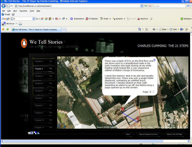
Free lesson plans help bring Google Earth into classrooms http://gelessons.com/ Penguin Books in the UK has even gone so far as to create a short story titled the 29 Steps by Charles Cumming (this story is a homage to The 39 Steps). The story is an adventure written and designed for Google Maps. You read the story though Google Map points displaying the locations of the story, with track lines taking you from one story location to the next. The 21 Steps (http://wetellstories.co.uk/stories/week1/)
Side note: Looking for information on concept mapping with technology? |
Send mail to cavanaugh@drscavanaugh.org with questions or comments about this web site. |
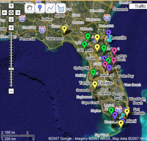 In the example to the right, Book Mapping is to create a map related to a book or collection of books, for example a map that tracks the locations in a novel.